
Trace a Plainfield Street by Address
A useful Plainfield street search moves from the physical parcel to the record that uses the right key. The City Tax Collector accepts a street, block and lot, or account number, while the county map uses roads, parcel shapes, blocks and lots. The Union County Clerk’s land index is different: it is indexed by party name, not by street address. Start with one address, write down the returned parcel identifiers, and repeat the process for the next lot only after the first record is clear. That method avoids treating a map label or a mailing address as proof that someone resides there.
- Enter the address at the Plainfield Tax Collector tax-bill search. Try the documented suffix forms, such as Street or St, if the first spelling fails, and record the block, lot, qualifier, account, and situs address shown with the bill.
- Open the Union County Public Map. Turn on Roads, Parcels, and Blocks and Lots, then use Identify or a parcel click to compare the street position and parcel key.
- Search the current owner’s name in the Union County Clerk land index. Check name variants, initials, and the available Soundex option before narrowing the date or document type.
- For a voter-status question, use New Jersey’s official Am I Registered? service for the named voter. A broader election-record request belongs with the Union County Board of Elections.
- For a past household snapshot, search a directory year and street section through Plainfield Public Library Local History. Compare the listed year, house number, and former street name with the parcel record before drawing a conclusion.
Each stop preserves a different fact. The Plainfield street directory sequence anchors a property, adds GIS map context, records parties from a deed, and ends with a dated directory listing. A missing result at one stop does not erase the others.
Search a Plainfield Street Tax Bill
The city’s tax-bill screen is the practical first address tool because it documents a street mode. It is not an owner-name search, and it asks the user to enter information in only one search area at a time. The result is a tax-bill match, not a confirmed household roster. For a fuller property card, contact the Plainfield Tax Assessor at 515 Watchung Avenue or call 908-753-3203. The research did not locate a verified city owner-name web portal, so that gap should remain part of the search plan.
| Plainfield tax field | Entry type | When it is required | Documented use |
|---|---|---|---|
| Street | Text | Required for street mode | Use one suffix variation at a time, including Street/St, Road/Rd, or Avenue/Ave. |
| Block | Text pair | Required with lot | Enter the block portion before the dot in block-and-lot mode. |
| Lot | Text pair | Required with block | Enter the lot portion after the dot, with a qualifier when applicable. |
| Qualifier | Text | Optional or conditional | Use the separate qualifier field shown with block-and-lot search. |
| Tax Account No. | Text | Required for account mode | Use account search separately rather than mixing it with address fields. |
In the street directory workflow, NJ Transparency property material can add property location, owner information, assessed land and building values, prior-year taxes, and classification. Its annual list is filed in January, so a transfer during the year may appear later. Daniel’s Law can also redact covered owner names in hosted parcel and tax-list data. A local assessor confirmation is the better route when online data is incomplete.
Note: Enter one documented tax-search mode at a time, then preserve the returned property key before moving to the map or deed index.
Map Plainfield Streets With Parcels
The Union County map is a geography tool, not an ownership directory. Its documented layers include Parcels, Blocks and Lots, Roads in Union County, Municipal Wards and Districts, Census Tracts, County Zoning, Cemetery, and Tax Map Attachments. A street can be oriented with the road layer, then each parcel can be clicked or identified and carried back to the city tax search. Owner fields may be absent or redacted, and the county says the map is reference data rather than a legal survey.
For an address beside a municipal line, compare the map’s municipal context with the tax result before taking any next step. This street directory step can show road and district context, but it does not publish a documented person-search form. The County Bureau of GIS is the support channel for map questions; the research lists Matt Mathan at 908-789-3691 and mmathan@ucnj.org. A boundary disagreement or missing parcel attribute belongs with that office, the municipal assessor, or the recorded plat, not with a guess from the map display.
Note: A parcel polygon establishes map context, while a survey, deed, and municipal record remain the sources for legal or administrative conclusions.
Follow Plainfield Street Deed Names
Once an address has yielded a parcel key and a current recorded owner, the land index can begin the next part of a Plainfield street directory search. Search the name as a grantee, inspect a published image when one is available, and keep the recording date, document type, book and page, or instrument number with the block and lot. The grantor on that transfer is a prior owner. Searching that person as an earlier grantee, while matching the legal description, makes a chain of title rather than a loose list of same-name results.
| Party name | Search last name with exact, starts-with, or Soundex options, and use initials or spelling variants where needed. |
|---|---|
| Document type | Use the Clerk’s documented category selector to distinguish a deed from a mortgage, lien, release, or plat. |
| Recording detail | Keep the recording date and either book/page or year, instrument number, and suffix. |
| Image status | A published image icon can appear. Public access may show a first page, while full-view access and older images have separate limits. |
The Clerk’s land-record search help shows the name-search choices and date-range limits used when narrowing an owner’s results.
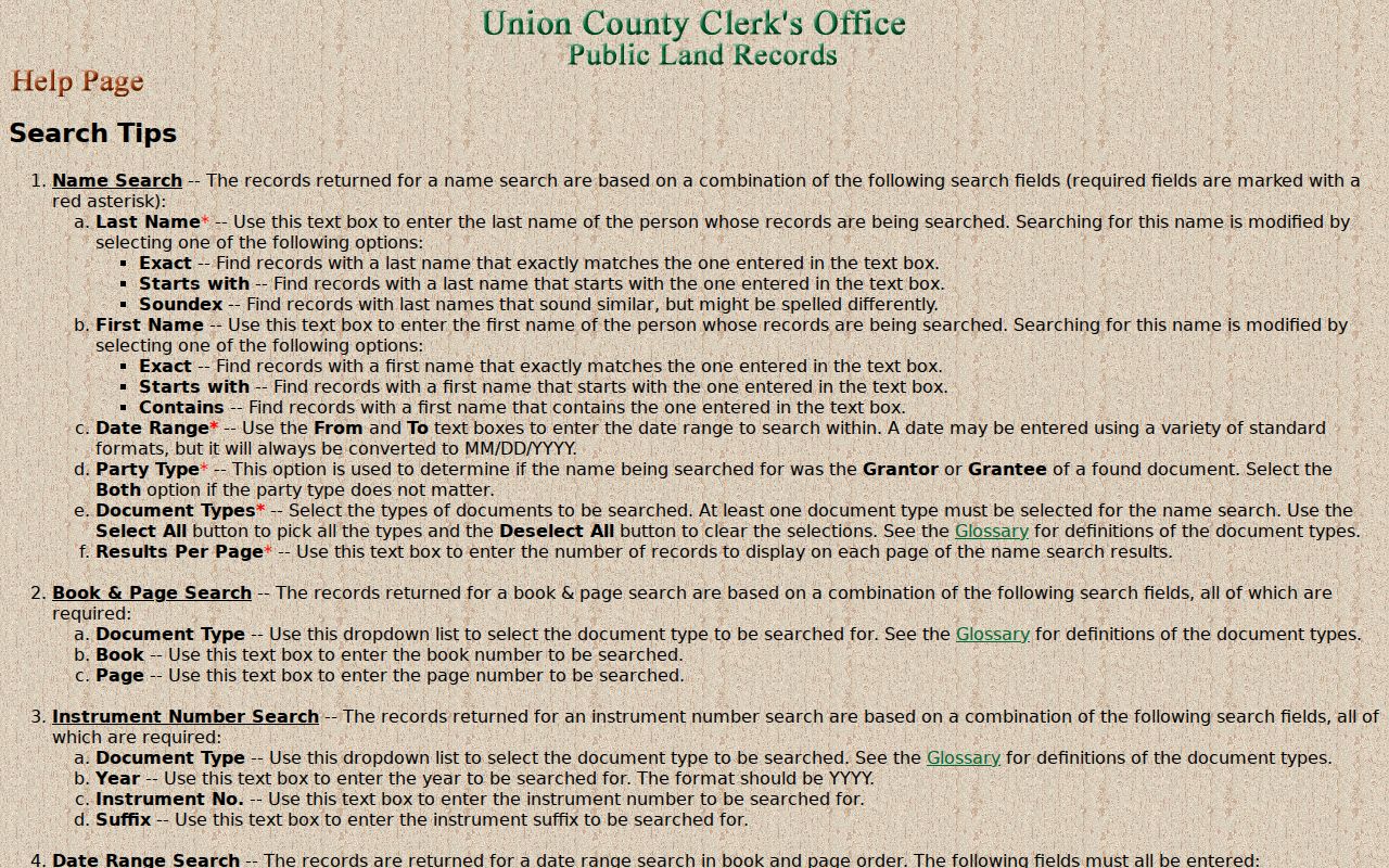
The help screen reinforces a key limit: the public web index is party-based. Work from the parcel owner’s name and legal description instead of expecting one street query to return every recorded transaction.
Mortgages, releases, liens, notices of sale, and plats can date activity around a property, but none alone proves occupancy. The portal warns that users should search spelling variants and imposes limits of 150 searches per hour and 500 per day. A deliberate parcel-by-parcel trail is more reliable than a broad, repeated name search.
Plainfield Street Records Compared
Records keyed to an address are not interchangeable. A Plainfield street directory uses the following documented routes for moving along a street. The access column matters because several useful records begin online but end at a counter, a targeted request, or the library.
| Address record | Custodian | Street-level evidence | Available route |
|---|---|---|---|
| Tax bill | Plainfield Tax Collector | Block, lot, account, tax status, and situs address | Online street, block/lot, or account search; 908-753-3214. |
| Property card | Plainfield Tax Assessor | Owner, mailing and situs fields, values, classification, and possible sketch | Counter or phone; no verified owner-name web portal was located. |
| Parcel map | Union County and NJGIN | Geometry, block/lot, nearby parcels, roads, districts, and map context | Public map service; reference only and subject to Daniel’s Law redactions. |
| Land index | Union County Clerk | Grantor/grantee, instrument, recording date, book/page, and type | Web index from June 1, 1977; Record Room land transactions from 1857. |
| Plats and maps | County Clerk Record Room | Lot layout, street context, subdivision, and legal description | Inspection or copy route in Elizabeth. |
| Permits and code files | Plainfield UCC/Inspections and Public Officer | Address, applicant or owner, work, inspection, condition, and notices | City counter or targeted OPRA request; full online index was not located. |
| Voter records | New Jersey and Union County BOE | Registration status and public election geography, subject to protections | State status check, county request, counter, phone, email, or OPRA. |
| Street directories | Plainfield Public Library | Historical address listings, businesses, and neighbors | Library print, microfilm, and digitized runs from the 1870s through 1982, with gaps. |
Keep the source date beside every field. A mailing field can lead to a notice recipient, and a directory can show an older listing, without either establishing the current people at the building.
Note: The block, lot, qualifier, and source date are the safest shared identifiers when a street entry is compared across offices.
Plainfield Street Address Terms
Plainfield property records often carry several address-like fields. Reading them correctly prevents an address search from becoming a false resident claim. New Jersey property systems use municipality, block, lot, and qualifier as a common parcel key, but a deed may also use a subdivision lot, recorded plan, or metes-and-bounds description. Preserve each version when the street number has changed or a result crosses a municipal line.
- Parcel
- A mapped piece of land represented in tax and GIS systems. Its block, lot, and qualifier help join map, tax, and recorded-land records.
- Situs address
- The physical location of the taxed property. It tells the tax and map systems where the land or building is located.
- Mailing address
- The address used for tax notices. It can differ from the situs address and is not a statement of who resides at the parcel.
- Plat
- A recorded map or plan that shows lot layout, streets, and related legal detail for a subdivision or mapped area.
- Criss-cross directory
- A reverse street listing that arranges historical entries by address rather than by surname.
The library’s digitized street sections are the historical companion to the modern parcel key. For the directory collection itself and its year-by-year context, use the Plainfield Directory Book rather than treating one reverse listing as a current result.
Plainfield Street Names and Postal Lines
Address history is a local geography problem. The 1887 directory identifies Essex Street as formerly Division Avenue, and the 1891 street section supplies endpoints and address ranges. Search both names in an older directory, newspaper, or deed trail. The historical directory heading can also reach North Plainfield streets, so the printed word Plainfield should not be treated as proof of today’s city boundary.
Postal geography has a similar limit. Plainfield addresses use 07060 and 07061, while North Plainfield’s local postal context also includes 07060, 07062, and 07063. A postal city and ZIP identify delivery routing, not the municipal parcel. Store the historic street and number, postal city and ZIP, and current municipality with block and lot as separate values. That small discipline is especially useful when a name or street label changes over time.
Note: USPS should verify an exact delivery ZIP, while the tax record and Union GIS establish the municipal parcel context.
Plainfield Street Permits and Notices
Address-specific municipal files can explain a property change that does not appear in a deed. Plainfield UCC/Inspections records can include a permit, certificate of occupancy, inspection, applicant or owner information, work description, and final inspection date when the file supports it. The previously used FastTrack portal is closed, and the research did not locate a complete public online permit index. Request the exact address and date range through the city counter or an OPRA request, adding block and lot, a permit number if known, and the particular record sought.
Property-maintenance and abandoned-property material is another separate city route. The local property code process can identify the owner of record, street address, last-known owner mailing address, vacancy or condition, and notice information. That is an administrative record about a property. It should not be repackaged as a list of everyone associated with the address. If the city needs clarification, a narrow request to the named custodian is more useful than asking for a new analysis.
Plainfield Street Voter Channels
Voter information follows an election address and district system, not a street-directory model. New Jersey’s online status service is for the registration-status question. Its live field inventory was not captured in the research, so no undocumented fields should be assumed. For a specific Union County election document or list, the Board of Elections has a counter, phone, email, English and Spanish request forms, and an OPRA route. The Board is at 271 North Broad Street in Elizabeth, can be reached at 908-527-4123 or ucboe@ucnj.org, and lists customer service from 8:00 a.m. to 4:00 p.m. on weekdays.
Ask for one identified record or date range and confirm the current format, fee, and required certification with the Board. Public election material is still subject to protected-address and identifier rules. Signatures, Social Security numbers, driver-license numbers, and Daniel’s Law-protected addresses are withheld. Ballot choices are never a public field, and party affiliation does not establish how a person voted.
Note: The Board’s request form and custodian, rather than an unverified street list, control what current election material can be released.
Plainfield Street Directory Limits
A Plainfield street directory can connect properties, recorded parties, and dated listings, but it cannot supply a complete household list. Tax and deed records focus on parcels and recorded interests. The tax mailing field is a notice route, not evidence of residence. DMV, utility, delivery, medical, and private school information are outside the public parcel chain. A public map may also omit a protected address or owner name. Treat absence as an access limit, not proof that no person or record exists.
Lawful personal use. Use address records for personal research, family history, estate work, civic questions, or to verify a document with its custodian. Never use a record trail to stalk, harass, threaten, or intimidate anyone.
Daniel’s Law, the New Jersey Address Confidentiality Program, court rules, and other confidentiality provisions can limit an otherwise public record. OPRA does not override those protections. A correction or access question should go to the tax office, Clerk, Board of Elections, city custodian, library, or archive that holds the original record.
When Plainfield Street Deeds Leave the Web
The online Union County land index begins June 1, 1977, while the Clerk’s Record Room holds land transactions from 1857 to the present. Pre-January 1986 images are still being added, so a web index entry does not guarantee a complete online image. For an older instrument or an un-imaged document, use the Record Room at 2 Broad Street in Elizabeth, call the Recording Office at 908-527-4787, or make the Clerk’s documented copy request. The research also identifies New Jersey Archives deed microfilm through 1900 and FamilySearch digitized county deed books as archival channels, with image availability and indexing varying by item.
The Clerk’s Property Fraud Alert is a separate preventive service. It sends an email or phone notice when a similar or same name appears in a recorded property document. An alert is a reason to inspect the actual Clerk record, not proof that a deed or lien is invalid. Save the source URL, access date, parcel key, and instrument citation as the address trail develops.
Note: A web cutoff or missing image calls for the Clerk’s counter, copy-request route, or archive channel, not an assumption of no record.